DEM and DSM files #414
paula-lelis
started this conversation in
General
DEM and DSM files
#414
Replies: 1 comment 1 reply
-
|
The model domain does not have to be square. It can be rectangular also. Set the no data to zero and if you are using ground cover, set the area to e.g. water or paved, not Nodata. |
Beta Was this translation helpful? Give feedback.
1 reply
-
|
Hello biglimp, thank you very much! |
Beta Was this translation helpful? Give feedback.
Sign up for free
to join this conversation on GitHub.
Already have an account?
Sign in to comment
Uh oh!
There was an error while loading. Please reload this page.
-
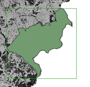
Hello, I have DEM and DSM files for a small zone with information only inside the perimeter's zone. To run UMEP properly, I understand that is necessary to simulate a square grid. In this case, I can insert my data into a big square that fits my perimeter. I would like to know if UMEP accept those areas with no data and if this affects the simulation. In case it is possible, I would like to know how to set this no data in the rasters. Best regards, Paula.
ps: In the attached file is possible to see the DSM available file, the square and the perimeter zone
Beta Was this translation helpful? Give feedback.
All reactions